Aquares 4D ground modelling
In many industrial applications
involving alluvial mining, dredging and marine construction the
application of this high quality survey method has opened new frontiers
in the way these projects are being designed and prepared based on the
capability of the Aquares resistivity method to generate high quality
geophysical data presented in a georeferenced 4D model. This 3D model
contains the base information of an integrated digital ground model
which is the foundation on which projects are being designed, tendered
and executed. Several examples are shown below with a wide variety of
applications including sand searches, port developments, pipe routes,
alluvial mining and dredging projects. A general map showing the locations of a larger number of projects is shown here.
Sand searches
Papua New Guinea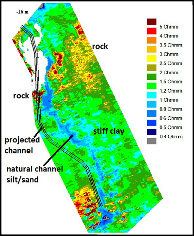
Two multinational contruction
companies interested in building an
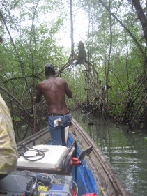
aluminium plant and a hydroelectric power station in a mangrove swamp
on an island near Papua New Guinea decided to carry out an extensive
classical soil investigation around the island to find suitable sand
for reclamation purposes. Various geophysical and geotechnical
surveys were realized involving seismics, sidescan sonar, multibeam
bathymetry, 77
vibocores and 116 boreholes. As the geophysical results were of poor
quality the vibrocores and boreholes were randomly placed.
After 2 years of investigations worth
12 million dollar, the final
report concluded that no significant volumes of sand were available.
The consultants then decided to carry out an Aquares resistivity survey
hoping to get a better geological understanding of the site using an
integrated 3D ground model. After 10 days of survey work the
resistivity results showed the location of more than 200 million m3 of
sand deposits. Moreover, the resistivity results also showed the
projected navigation channel leading to the island to be cutting a
number of rocky areas (see figure). By changing the design of this
channel shifting it about 300 m to the east very expensive dredging
costs were avoided. Cost savings based on resistivity results have been
estimated at more than 1000 times the survey costs.
Port developments
Limbe port development
In Limbe, Cameroon the decision was
taken to build a port for the
maintenance of offshore oil drilling platforms. In a first instance the
port was designed and tendered without any detailed previous knowledge
of the geological characteristics of the construction site. A marine
construction company bidding for this project and understanding the
importance of the lack of geological information with regards to their
cost estimates, decided to work out an
integrated 4D groundmodel based on Aquares resistivity measurements.
A complete 4D model of the
construction site was generated based on the
resistivity results completed with boreholes. The picture shows a
number of horizontal resistivity sections at -10, -12 and -16 m
relative to chart datum as well as a vertical section showing the
thicknesses of some of the geological structures. The construction site
consists of solid basalt overlain by weathered basalt and fine to
coarse sediments as confirmed by a limited number of boreholes.
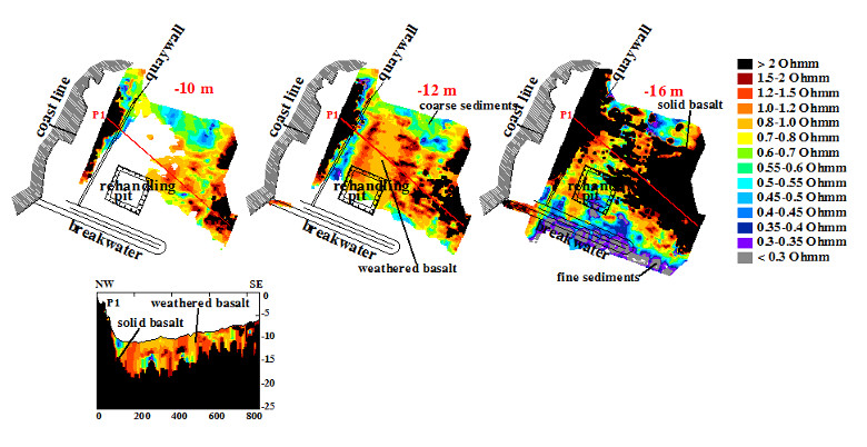
Based on the original design it appeared that dredging operations and construction of the quaywall would be extremely expensive due to the presence of very hard solid basalt. After some calculations and various communications with the client's consultants, it then was decided to modify the design to take advantage of the location of the solid basalt for the foundation of the quaywalls and softer rock and sediments for the turning basin and rehandling pit.
By adjusting port design to the
geological conditions as defined in the
integrated digital 4D ground model it was estimated that more than 50%
of the construction costs were saved.
 Buenaventura
port development
A company specialised in port
operations and logistics planned to build
a new port in a mangrove swamp in Buenaventura, Colombia. In order to
be able to correctly and economically design quaywalls, turning basins
and other infrastructure they decided a detailed integrated 4D ground
model was required based on Aquares resistivity information.
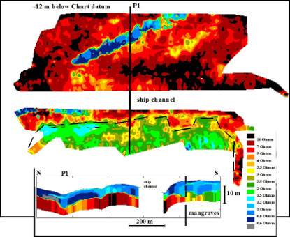
 The picture shows a horizontal
and a
vertical resistivity section of
the construction site. The high resistivity values (green-red)
correlate with siltstone rock while the low resistivity values (blue)
correlate with muddy sediments as confirmed by boreholes. Based on this
type of sections dredge volumes of sediment and rock can be calculated
for the turning basin north of the existing ship channel and quaywalls
can be designed south of the ship channel based on accurately known
rock head levels.
The picture shows a horizontal
and a
vertical resistivity section of
the construction site. The high resistivity values (green-red)
correlate with siltstone rock while the low resistivity values (blue)
correlate with muddy sediments as confirmed by boreholes. Based on this
type of sections dredge volumes of sediment and rock can be calculated
for the turning basin north of the existing ship channel and quaywalls
can be designed south of the ship channel based on accurately known
rock head levels.Interestingly, the horizontal as well
as the vertical section both show
different resistivity values for the rock heads underlying the
mangroves (green-yellow: 1.5-3.5 Ohmm) as compared to rock head
resistivity values (red: >5 Ohmm) underlying open water north of the
ship channel. This phenomenon is most likely associated with low pH
values in mangrove areas caused by sulphate concentrations generated by
the decomposition of biologic tissue of marine animal life living in
the mangrove swamp. If no appropriate precautions are taken during
dredging operations, this potential acid sulphate hazard may become an
accute menace to the existence of marine life in the surrounding area.
It is obvious that without the
application of high quality geophysics
presented in a 4D ground model these potential environmental hazards
most likely would have been detected only during execution of the
project when actually unleashed by the dredging operations.
 Eden
port development
The Eden Port Development project was
a $25 million port construction
project managed by NSW Trade and Investments (Crown Lands) in New South
Wales, Australia, involving the extension of an existing breakwater,
quaywalls and mooring dolphins, associated dredging operations and a
fixed or floating wave attenuator. Originally the port design was based
on a detailed site investigation including a classical seismic
reflection survey, a side scan sonar survey, magnetometer survey, 21
boreholes and 15 vibrocores. Crown Lands then decided to carry out an
additional site investigation integrating all existing information into
a 4D ground model based on Aquares resistivity results to help mitigate
latent geological risks specific to the project.
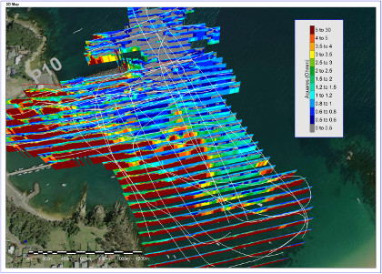
The picture shows some of the results
presented using the Encom PA
software package. They clearly show the extent and thickness of high
resistivity rock heads and gravels. Significant differences were noted
between the seismic results and the high quality resistivity (Aquares)
results. The use of an Aquares based integrated 4D ground model on this
specific project has led to an estimated 20% savings in dredging and
piling costs.
 Pipe
routes
A construction company contracted to
build a power plant along the
coast in Ghana was required to include an intake and outfall for
cooling water of the power plant. The intake and outfall tunnels
were to be drilled horizontally at about 10 m depth starting from the
beach. As drilling tunnels should be done in solid rock while the
retrieval of the drilling equipment can more easily be done in
softer sediments where a simple hopper suction dredge would be capable
to uncover the drilling equipment, the construction needed good
geological information to optimize the tunnel routes. As the classical
seismic and borehole information provided by the client where largely
insufficient for the purpose they ordered an Aquares resistivity survey
to generate a georeferenced 4D integrated ground model of the
construction site subsurface.
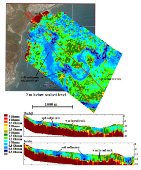
 The vertical resistivity sections
generated across the 4D model clearly
shows sold rock heads (high resistivity values) covered by weathered
rock (intermediate resistivity values) and soft sediments (low
resistivity values). The horizontal resistivity section at 2 m below
seabed level shows the position and extent of a palaeoriver system
filled with low resistivity soft sediments meandering in between solid
and weathered rock heads.
 Based on high quality resistivity
information combined with
borehole and other geotechnical information into a georeferenced
integrated 4D ground model, the tunnel routes could be optimized
saving millions of dollars in drilling and dredging costs.
Alluvial mining
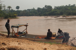
After several months of poor
productivity on the Tshikapa river in the West-Kasai, DRC Congo, a
diamond mining company
decided they needed an Aquares resistivity survey to map the
diamondiferous gravels in their concession. A complete 4D model of the
river was realized in a 5x5 m2 grid. Low 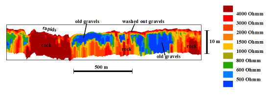 resistivity structures on the
vertical resistivity section correspond with high grade old
diamondiferous gravels
resting on high resistivity bedrock and overlain by high resistivity
washed out young (mobile) river gravels on the river bed.
 resistivity structures on the
vertical resistivity section correspond with high grade old
diamondiferous gravels
resting on high resistivity bedrock and overlain by high resistivity
washed out young (mobile) river gravels on the river bed.
 By focussing the dredging operations
on the more promising geological structures as mapped in the 4D
resistivity model, the productivity of the mining operations were
significantly increased.
 Dredging
After a detailed site investigation
involving a number of classical
geophysical surveys and a borehole campaign, ACP (Autoridad del Canal
de Panama) tendered a dredging project in the access channel leading to
the Miraflores locks. A group of dredging companies interested in the
project realised an additional investigation including an Aquares
based integrated 4D ground model.
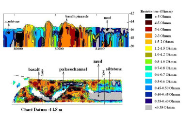
 Some of the results are shown in the
horizontal and vertical
resistivity section of the picture shown. The vertical section shows
the location and extent of hard basalt rock, softer mudstones and soft
mud. The horizontal section shows the lateral extent of the geological
formation at dredge level. It clearly shows a natural palaechannel cut
into basalt rock by the Rio Chagres in his course from Lake Gatun to
the Pacific Ocean in geological times when Pacific sealevels were far
lower than they are now.
Some of the results are shown in the
horizontal and vertical
resistivity section of the picture shown. The vertical section shows
the location and extent of hard basalt rock, softer mudstones and soft
mud. The horizontal section shows the lateral extent of the geological
formation at dredge level. It clearly shows a natural palaechannel cut
into basalt rock by the Rio Chagres in his course from Lake Gatun to
the Pacific Ocean in geological times when Pacific sealevels were far
lower than they are now.This type of high quality geophysical
information complemented with a
limited number of well targeted boreholes allowed the dredging
contractor
to accurately calculate the geological risks. As a consequence, this
dredging project was awarded at only 30% of the original budget
estimate suggested by ACP in the tender documents based on their own
site investigation excluding advanced geophysics (Aquares) based
integrated 4D ground modelling.
Conclusion:
Aquares is an extremely powerful and
versatile geophysical exploration method. It is very effective in
reducing geological risks. For most geological site investigations an
Aquares resistivity survey tends to be the best value-for-money
solution generating high quality and very clear results where other
geophysical methods often tend to fail.
Client testimonials:
"We are finally done with the guesswork!"(Quote from USACE after a successful Aquares resistivity survey following previous inconclusive survey campaigns)
"Boskalis uses for different projects geo-electric surveys to quantify and qualify rock outcrops. For the geological setting near the coast of Luderitz (Namibia) geo-electric survey is preferred above conventional reflection seismic since gravels above the rock outcrop might diffuse the signals. Also it is believed that reflection seismic will not give information about the rock strength characteristics, while geo-electric survey data can."
(Advise from Boskalis BV to Namport with regards to the geophysical methods to be used in the port of Luderitz)
"We herewith confirm that Demco NV has carried out a resistivity survey for us in the acces channel of the Port of Buenaventura, Colombia in view of a dredging project. The results clearly showed the locations of rock and sediments as well as different qualities of rock."
(Declaration from Jandenul NV after a successful Aquares survey in the port of Buenaventura)
"We herewith confirm that Demco NV has carried out a resistivity survey for us in the Pacific access channel in Panama. Using the resistivity results the different sedimentary and rock structures could be distinguished. The resulting 3D model of the subsurface proved useful in determining volumes for each of the structures."
(Declaration from DEME NV after a successful Aquares survey in the Panama Canal)
"We herewith confirm that Demco NV has carried out a resistivity survey for us in the port of Limbe, Cameroon. The resistivity results were considered very useful in defining the nature of the subsurface as a foundation for the quaywalls to be constructed."
(Declaration from Interbeton BV with regards to the construction of the port of Limbe the design of which being based on a 3D integrated ground model provided by Aquares resistivity information.)
"This is to acknowledge that OEMG mapped significant parts of the Botany Port seabed, operating around working vessels in a few days utilising the Aquares system. Works were completed on time and within budget and our objectives were met: OEMG's mapping allowed assessment of the condition of the subsoil directly adjacent to the wharf structures allowing us to verify the stability of the structures for current and future use."
(Declaration from NSW Ports after an Aquares resistivity survey in Botany Port, Sydney.)
