
Demco NV
Demco NV is an engineering
consultancy company providing worldwide
geological and geophysical services to dredging operations, port
development projects, alluvial mining projects, pipe/cable trenching
operations and other projects requiring shallow geological information.
Most of Demco's services are related to two specific and unique geophysical methods: the Aquares and Rheocable methods.
Rheocable
The Rheocable is a marine survey
method used to accurately determine nautical depths in the presence of
fluid mud. The Rheocable method was developed by MDCE bvba and Demco NV
joined together as THV Nautic to cope with current problems and
inaccuracies resulting from classical bathymetric surveys involving
fluid mud in a large number of European and American ports. The
principles of the Rheocable method are explained in a separate section.
Aquares
Aquares is a unique marine resistivity method developed by Demco NV for marine and fluvial geological exploration. At this moment Aquares is considered the only existing marine resistivity method worldwide accepted on dredging markets. It is worldwide applied by Demco NV, in the USA in association with Arc Surveying &Demco NV has developed a unique presentation tool to access Aquares based geological twins or Geotwins (3D integrated digital geological models) and correlate the Aquares results with other existing geological, geotechnical, geophysical, geochemical and bathymetric information. The current version of this presentation tool is named 3DScanner or Macondo in most of the world, ArcGeoTwin in the USA and MyGeoTwin in Australia.
The principles of Aquares resistivity sounding are explained here.
The main advantages of Aquares as compared to other geophysical methods are the following:
- Aquares provides not only
quantitative information (depths and
thicknesses) but also qualitative information, distinguishing different
sediment and rock types
- flexibility: Aquares can operate successfully:
- in shallow as well as in deep
water:
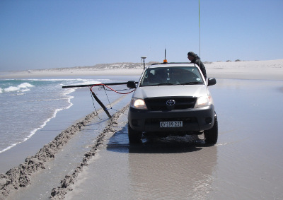
Whereas seismic reflection methods suffer from "multiple reflections" in shallow water, Aquares works perfectly in shallow water. As long as the cable is wet the system functions, even in a shallow ditch. The picture shows a diamond exploration resistivity survey along a beach in the Noordkaap, South-Africa.
- in gravel:
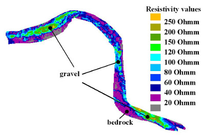
Gravel is known to cause diffractions on seismic records obscuring seismic results while Aquares resistivity measurements do not suffer any negative effects at all and are perfectly capable of determining even the base of the gravel deposits. This makes the Aquares resistivity methods very attractive to alluvial gold and diamond mining exploration applications. The example shows a horizontal resistivity section at 2 m below river bed level showing diamondiferous gravel on the Sankuru river in DRC Congo.
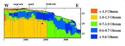
- caprock:
Cemented layers at the seabed surface completely block all seismic energy while electrical currents injected by the Aquares resistivity method easily find their way even through thicker cap rock. For this reason Aquares is the preferred geophysical method for sand searches, pipe route surveys and other geological exploration campaigns in areas with common cap rock occurrences such as the Persian Gulf or West-Australia.
- without "gas masking" problems:

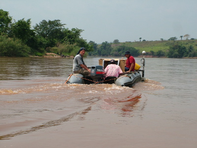
Gas bubbles generated by rotting vegetation in organic rich sediments generate diffractions on the seismic response significantly limiting seismic penetration. As the Aquares resistivity method is not affected by these bubbles, it tends to be successful even in mangrove swamps and other types of organic rich sediments. The example shows the results from a combined resistivity-boomer survey in Luderitz, Namibia where the resistivity results clearly show bedrock levels where the boomer fails due to gas masking effects in diatomaceous silt.
- without geological limitations
such as velocity inversions:
 Refraction seismic methods
are notoriously inaccurate in general and
require conditions involving a strict sequence of geological layers
with acoustic velocities continuously increasing with depth. Velocity
inversions involving high velocity structures on top of low velocity
structures generate erroneous refraction results. Due to the nature of
resistivity methods velocity inversion situations are easily and
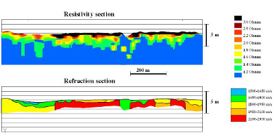
correctly handled by the Aquares method. The example shows a
resistivity and refraction example from Flinders Port, South-Australia
where the refraction results failed to detect a high velocity
cemented shell bed at the seabed surface, while boreholes perfectly
confirmed the resistivity results.
Refraction seismic methods
are notoriously inaccurate in general and
require conditions involving a strict sequence of geological layers
with acoustic velocities continuously increasing with depth. Velocity
inversions involving high velocity structures on top of low velocity
structures generate erroneous refraction results. Due to the nature of
resistivity methods velocity inversion situations are easily and
correctly handled by the Aquares method. The example shows a
resistivity and refraction example from Flinders Port, South-Australia
where the refraction results failed to detect a high velocity
cemented shell bed at the seabed surface, while boreholes perfectly
confirmed the resistivity results.
- in high noise environments such
as surf zones and heavy weather
conditions:
Whereas seismic results are drowned in noise generated by high energy environments such as surf zones, the seabed towed cables used by the Aquares method are far less affected by rough sea conditions. This makes Aquares very attractive for applications such as pipe route landfalls and diamond exploration in coastal areas.
- Thanks to it's flexibility Aquares works fast and therefore tends
to
be cheaper
- Aquares is more accurate as compared to seismics
- Aquares provides high precision georeferenced 4D models (GIS) of
the survey area with
presentations in vertical as well as horizontal sections. The next video
illustrates the possibilities of Aquares 4D presentations
The capability of Aquares to generate high precision georeferenced 4D
models (X,Y,Z, resistivity) has opened new frontiers in the industry.
In many industrial
applications involving alluvial mining, dredging and marine
construction these 4D resistivity models are used as base information
for integrated digital ground models and have become the foundation on
which projects are being designed, tendered and executed. This is
further explained and illustrated in the next
section.
Note: In Australia Aquares has won the NSW Business Chambers' 2015 Award for Excellence in Innovation.